
Towing the East Coast: A 7-Day Caravan Itinerary from Hobart to St Helens
There’s something utterly compelling about a Tasmanian east coast road trip—traversing a landscape where towering sea cliffs meet pristine white beaches, wombats waddle across campsites at dusk, and every corner reveals another postcard-perfect bay. This route takes you from Hobart’s doorstep through some of the island’s most dramatic coastal scenery, finishing at the laid-back fishing village of St Helens.
Our 7-day itinerary is designed for caravans and hybrids, with every campground carefully chosen to accommodate your rig. Whether you’re towing a full-size caravan or a campervan, the roads are sealed throughout, with only short unsealed sections into specific campgrounds. And if you’ve got more time up your sleeve? We’ve included extension options for each leg so you can stretch this into a proper 10-14 day adventure.
Total Distance: Approximately 420 km
Best Time to Travel: October to April (warmer weather, longer daylight hours)
If you wish to start this East Coast road trip in St Helens, we have provided a summary table of the base itinerary near the bottom of the page (see now).
7-Day Itinerary at a Glance
Base Itinerary Stays
- Day 1-2: Nubeena Ex-Serviceman’s Club Campground (or Fortescue Bay)
- Day 3-4: Triabunna Self-Contained Camping Area
- Day 5-6: Freycinet Golf Club Campground
- Day 7: Dora Point Camping Area, Binalong Bay
Extension Options (10-14 Day Trip)
- 1-2 Extra Nights – Tasman Peninsula: Add Cape Raoul Track and/or Cape Hauy Track (world-class coastal walks)
- Extra Night – Before Triabunna: Orford (Eastcoaster Resort or similar)
- Overnight on Maria Island: Darlington Campground (tent camping only)
- Extra Night – Before Coles Bay: Bicheno caravan parks (penguin tours & Douglas-Apsley NP)
- 1-2 Extra Nights – Bay of Fires: Douglas River Campground (remote, off-grid)
Hobart to St Helens Road Trip Map
To aid in your planning, we have carefully prepared a map of the route. Also on the map are the campground locations, points of interest and starting points for walks.
Day 1: Hobart to the Tasman Peninsula
Journey into Convict Country
The Run
Hobart → Nubeena or Fortescue Bay 200km | 1.5–2 hours via the Arthur Highway (for both options)
On the Road
An early start from Hobart sets you up perfectly for this first day. Head north out of Hobart on the Tasman Highway before branching onto the Arthur Highway through the historic township of Sorell. The road is sealed and well-maintained throughout, winding through farmland and bush before the dramatic coastal cliffs of the Tasman Peninsula come into view.
Make time for a stop at Richmond on your way through if you have not already visited it. Richmond is a perfectly preserved Georgian village, a short detour well worth the 20 minutes. The Richmond Bridge, built by convict labour in 1823, is Australia’s oldest bridge still in use—wander across it, grab a coffee, and soak up the history before pushing on.
Aim to arrive at your campground by early afternoon, giving you time to set up and still have a good few hours to explore.
The Stay
Nubeena Ex-Servicemen’s Club Campground — 2 nights
A caravan-friendly unpowered site right in the heart of Nubeena township. The club offers clean facilities, hot showers and toilets (during open hours only), and a welcoming atmosphere. It’s perfectly positioned as a base for exploring the peninsula without the remoteness of bush camping. Arrive early during peak season as it’s popular with tourers.
Alternative: If you’re after something more secluded and don’t need power, Fortescue Bay Campground is a stunning national park site nestled in a sheltered bay with beach access. The unpowered sites suit all rig sizes, and waking up to the sound of waves is hard to beat. Note that pets are not permitted in national parks. You need to book this site (details are provided on the linked page).
The Highlight
After settling into camp and grabbing some lunch, make your way to Port Arthur Historic Site. This former convict settlement is Tasmania’s most significant heritage attraction and deserves at least 2-3 hours of your time. The entry fee (adults $53) includes a guided walking tour and a harbour cruise—both are excellent and provide context you won’t get from wandering alone. You may book online.
Walk through the preserved buildings, imagine the harsh realities of convict life, and don’t miss the eerie Isle of the Dead cemetery just offshore. The site is beautifully maintained and genuinely moving—there’s a reason it’s UNESCO World Heritage-listed.
The afternoon light is particularly beautiful on the old sandstone buildings, and you’ll likely have the place a bit quieter than the morning tour bus rush. Take your time here—it’s one of those places that rewards a slow, thoughtful visit.
If you’ve got time before heading back to camp, stop at White Beach near Nubeena for a sunset stroll. The long stretch of white sand is perfect for unwinding after your first day on the road.
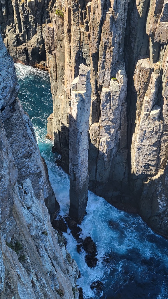
Extension Option: Add an extra night (or two) to tackle the peninsula’s world-class coastal walks. The Cape Raoul Track (14 km return, 5 hours) is one of Tasmania’s most spectacular walks, taking you to clifftop views where 300-metre dolerite columns plunge into the Tasman Sea. The trailhead is about 30 minutes from Nubeena down a well-maintained gravel road—unhitch the van and drive out in your tow vehicle. With a third night, you can also explore the Cape Hauy Track (10 km return, 4 hours), which takes you to the famous Candlestick and Totem Pole sea stacks. Staying 3-4 nights total gives you time to properly experience both walks without rushing.
Day 2: Tasman Peninsula Sightseeing
Nature’s Sculpture Gallery
The Run
Minimal driving today—everything is within 30–40 minutes of Nubeena.
On the Road
Keep the rig parked at your campground and use your tow vehicle to explore. The roads around the peninsula are sealed and well-signposted, making navigation straightforward. After yesterday’s deep dive into convict history at Port Arthur, today is all about the peninsula’s spectacular natural formations.
The Stay
Nubeena Ex-Servicemen’s Club Campground — second night
Return to your base for another evening. Use the club’s facilities to clean up after a big day of exploring, and consider grabbing a counter meal at the club if you can’t be bothered cooking.
The Highlight
Start your day at the Tasman Arch, where the Southern Ocean has carved a spectacular natural bridge from the dolerite cliffs. A short boardwalk from the car park takes you to the viewing platform—it’s an easy 5-minute stroll suitable for all ages.
Next, head to Devil’s Kitchen—a deep coastal chasm where waves crash and boom in the enclosed space. The viewing platform here offers a dizzying look straight down into the churning water below.
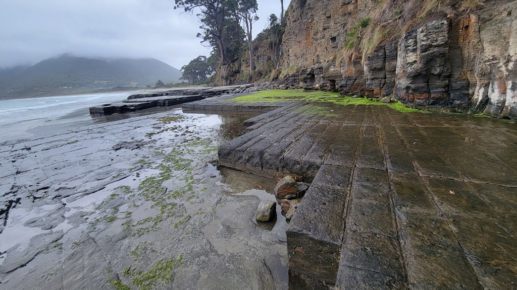
Finish the “Big 3” at the Tessellated Pavement at Eaglehawk Neck, a geological wonder where the flat rock platform has cracked into near-perfect rectangular tiles. Time your visit for low tide to see the formations at their best—the concave pan formation on the seaward side and the convex loaf formation closer to shore are equally impressive.
After the Big 3, head to the Remarkable Cave near the southern tip of the peninsula. A short walk from the car park leads to a sea cave with a natural arch framing views of the ocean—particularly stunning in afternoon light. It’s worth timing your visit for later in the day when the sun streams through the opening.
If you’ve got time and energy left, the short walk to Waterfall Bay (3.4km return) offers beautiful coastal views and a chance to see a waterfall cascading onto the beach—though the flow varies depending on recent rainfall.
Extension Option: Add another night and dedicate a full day to the Three Capes Track experience. While the full multi-day hike requires booking well in advance, day-trippers can access sections of the track. Alternatively, book a boat cruise for a different perspective of these towering dolerite cliffs (e.g., scenic tour – wildlife, caves & sea cliffs)
Day 3: Tasman Peninsula to Triabunna
Onto the East Coast
The Run
Nubeena → Triabunna 108 km | 2 hours via the scenic inland route
On the Road
Head back the way you came, retracing your route to Sorell before joining the Tasman Highway toward Triabunna. The road is sealed and well-maintained throughout, winding through coastal scenery and small townships.
This is a straightforward drive with good facilities along the way. You’ll pass through Orford, which makes a pleasant place to stretch your legs or grab a coffee. The route is suitable for all caravans and offers plenty of opportunities to pull over and enjoy the coastal views.
The Stay
Triabunna Self-Contained Camping Area — 2 nights
A no-frills, budget-friendly camping area right in town that’s perfect for self-contained rigs of all sizes. The sites are large enough for large caravans, and the location puts you within walking distance of shops, cafes, and the Maria Island ferry terminal. Facilities are basic—so ensure you’re genuinely self-sufficient before arriving. You must be fully self-contained to stay here. Your camping fees are donated to the Royal Flying Doctor Service.
You should try The Fish Van, just a short walk away, for fish and chips.
If you’d prefer powered sites and more comprehensive facilities, the Triabunna Cabin & Caravan Park nearby offers both powered and unpowered sites with all the usual amenities.
The Highlight
Arriving in Triabunna feels like stepping back in time. This small fishing town services the Maria Island ferry and not much else, giving it a wonderfully unhurried atmosphere. Take a walk along the waterfront, watch the fishing boats come and go, and grab some fresh fish and chips for dinner.
The town has a good IGA for restocking supplies, fuel, and basic services—make use of it before tomorrow’s Maria Island adventure.
If you arrive with time to spare, the Spring Bay Hotel overlooking the marina is a classic Aussie pub worth a visit for a cold drink and a chat with the locals. The sunset views across Spring Bay from the beer garden are hard to beat. Best of all, it is across the road from the campground.
Extension Option: Add a night at Orford before reaching Triabunna. Stay at the Eastcoaster Resort or one of the other caravan parks in town, and spend an afternoon exploring the Raspins Beach area or taking a scenic drive up to the Three Thumbs Lookout for panoramic views over the Prosser River and Mercury Passage. Orford is a quietly beautiful spot that most travellers rush straight through.
Day 4: Maria Island Day Trip
Tasmania’s Wildlife Wonderland
The Run
No driving today—leave the van and car at camp and walk to the ferry terminal.
On the Road
The Maria Island ferry departs from the Triabunna waterfront, just a short walk or drive from your campground. Ferries run multiple times daily during peak season, with reduced services in winter. It is best to book your ferry in advance, especially during school holidays and summer weekends—it’s a popular trip. A day return is $56.50 for adults and $34.50 for children.
The crossing takes about 30 minutes and delivers you to Darlington, the island’s only settlement and former convict probation station.
You will need a national park pass to get onto the island. At checkin they do ask you to produce your pass if you do not buy one from them.
The Stay
Triabunna Self-Contained Camping Area — second night
Return to your campground after a big day exploring the island. You’ll be glad of a comfortable bed after all the walking.
The Highlight
Maria Island is an absolute gem—a car-free national park where wombats, Cape Barren geese, and wallabies vastly outnumber humans. The moment you step off the ferry at Darlington, you’re in a different world.
Start with a wander through the Darlington Probation Station, where convict-built structures tell the story of Tasmania’s penal past. The ruins are beautifully preserved and entirely accessible on foot.
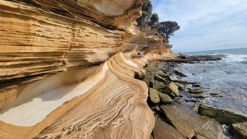
For walkers, the Painted Cliffs (3km return from Darlington) are an absolute must-see. The sandstone cliffs are stained with iron oxide in swirling patterns of rust, orange, and cream—utterly mesmerising and best viewed at low tide when the water is calm.
If you’re feeling energetic, the Bishop and Clerk summit hike (11km return) is one of Tasmania’s finest day walks. The track climbs steeply through forest before emerging onto the dolerite cliffs with 360-degree views across the island and mainland. It’s a proper workout—allow 4-5 hours return and carry plenty of water. Be warned that just before the summit, there is a short section of a rock scramble. It’s not too difficult.
Wildlife encounters are virtually guaranteed. Wombats graze openly in broad daylight around Darlington, utterly unbothered by human presence. Keep your distance and don’t feed them, but enjoy the rare opportunity to observe these magnificent animals up close. We even saw a Tasmanian devil.
Pack a picnic lunch, plenty of water, sunscreen, and layers—the island can be significantly cooler and windier than the mainland, especially on the exposed clifftops.
Extension Option: Stay overnight on Maria Island itself. The Darlington campground offers unpowered sites (no caravans—tent camping only) with basic facilities. Spending the night gives you time to explore further afield, experience the island at dawn and dusk when wildlife is most active, and truly disconnect from the modern world. You’ll need to carry all your camping gear and food on the ferry, but the experience is unforgettable.
Day 5: Triabunna to Coles Bay
Gateway to Freycinet
The Run
Triabunna → Coles Bay 102km | 1.5 hours via the Tasman Highway and Coles Bay Road
On the Road
A short and scenic drive north along the Tasman Highway before turning off toward Coles Bay. The Tasman Highway is sealed and well-maintained, with stunning coastal views appearing as you round each bend.
The turn-off to Coles Bay is clearly signposted. The Coles Bay Road is sealed throughout and winds through bushland before revealing glimpses of the pink granite Hazards rising dramatically above the coast. The final approach into Coles Bay, with the mountains framed against Coles Bay itself, is genuinely breathtaking—one of those moments where you instinctively reach for the camera.
The Stay
Freycinet Golf Club Campground — 2 nights
A hidden gem that many travellers miss entirely. This small, no-frills campground sits just outside Coles Bay township and offers unpowered sites suitable for caravans in a peaceful bush setting. You need to be self-sufficient as there are no facilities. The relaxed atmosphere and significantly lower price compared to the commercial parks make it a favourite among long-term travellers.
The campground is within driving distance of the Freycinet National Park entrance. Ensure that you have some cash to pay the camping fees.
For more information about this campground, see our information at Freycinet Golf Club Campground.
Alternative: If you need powered sites or more comprehensive facilities, Iluka on Freycinet Holiday Park caters well to caravans and offers a full range of amenities.
The Highlight
Settle into camp, then take an evening stroll down to Muirs Beach or Richardsons Beach in the national park. These stunning white-sand beaches with turquoise water and the pink granite Hazards as a backdrop are what Tasmanian tourism dreams are made of. The beaches are easily accessible from the day-use area just inside the park entrance—park fees apply, but they’re valid for 24 hours.
Coles Bay township itself is tiny but functional—there’s a general store for supplies, a bakery that does excellent pies, and a couple of cafes and restaurants if you’re after a meal out. Grab some fresh seafood for dinner and enjoy it back at camp as the sun sets.
Extension Option: Add a night at Bicheno on your way to Coles Bay. Stay at one of the caravan parks in town and explore the Bicheno Blowhole, take a penguin tour at dusk (little penguins nest in the rocks around town), and visit the Douglas-Apsley National Park for waterhole swimming and bushwalking. Bicheno is an underrated stop that deserves more than just a drive-through.
Day 6: Explore Freycinet National Park
Tasmania’s Crown Jewel
The Run
Minimal driving—park the rig and spend the day in the national park.
On the Road
Drive your tow vehicle the short distance to the Freycinet National Park day-use area. The park entry fee covers 24 hours, so make the most of it (if you have your two-month Holiday Pass, you are covered). Arrive early to secure parking—the car park fills quickly during peak season, especially on sunny summer days.
The Stay
Freycinet Golf Club Campground — second night
Return to your campsite after a full day exploring. The peaceful setting is perfect for unwinding after a big walk, and the lack of crowds makes for a restful evening.
The Highlight
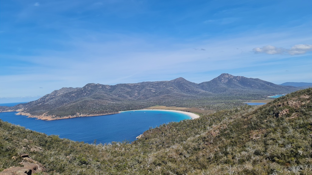
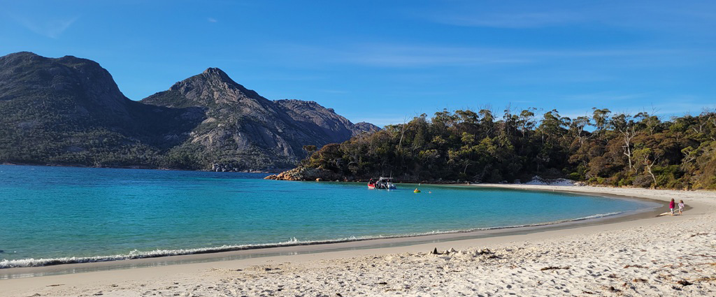
The Wineglass Bay Lookout (the first photograph on this page) is Tasmania’s most photographed view, and with good reason. The track from the car park climbs steadily through the forest for about 1.5km before emerging at the saddle between two peaks. Suddenly, the perfect crescent of Wineglass Bay unfolds below—white sand, azure water, and the curve of the bay framed by mountains. It’s genuinely stunning, and no photo quite captures the scale and beauty of seeing it in person.
The walk to the lookout takes 1–1.5 hours return and is moderately graded—plenty of steps, but manageable for most fitness levels.
If you’ve got the legs for it, don’t stop at the lookout. Continue down to Wineglass Bay Beach itself (an additional 2.5 km return). The descent is steep but well-maintained, and standing on that perfect beach with nobody else around (if you’re lucky) is worth every step. The water is shockingly cold year-round, but plenty of people brave a quick dip.
For the truly committed, the Wineglass Bay and Hazards Beach Circuit (11 km loop, 4–5 hours) is one of Tasmania’s best day walks. From Wineglass Bay, the track continues over the isthmus to Hazards Beach on the opposite side of the peninsula before looping back through bushland to the car park. You’ll need to be reasonably fit and carry plenty of water, but the variety of landscapes and relative solitude on the Hazards Beach section make it exceptional.
Back at the day-use area, don’t miss Honeymoon Bay and Sleepy Bay—both are short walks from the car park and offer stunning coastal scenery with far fewer crowds than Wineglass Bay.
Extension Option: Walk to the far end of Wineglass Bay Beach. The view from here towards the Hazards is stunning. Alternatively, tackle Mount Amos (3 km return but very steep) for the ultimate aerial view of Wineglass Bay—this is a serious scramble over granite boulders and not for the faint-hearted, but the 360-degree panorama from the summit is unforgettable.
Day 7: Coles Bay to St Helens
Journey’s End at the Bay of Fires
The Run
Coles Bay → Dora Point Camping Area, Binalong Bay 121 km | 2 hours via the Tasman Highway
On the Road
Your final day’s drive continues north along the spectacular east coast. The Tasman Highway hugs the coastline, offering glimpses of beaches and bays between the trees. The road is sealed throughout and suitable for all vehicles.
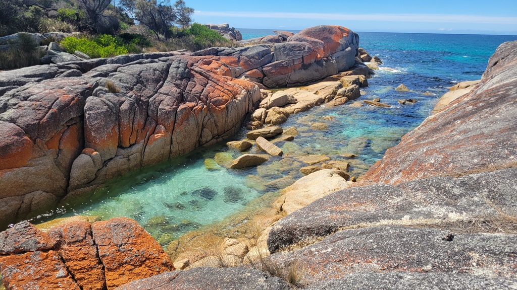
As you approach St Helens, the landscape opens up and the famous orange lichen-covered boulders of the Bay of Fires begin to appear. This stretch of coastline is consistently ranked among the world’s most beautiful beaches, and it’s easy to see why.
Rather than staying in St Helens township itself, we recommend continuing a few extra kilometres to Binalong Bay at the southern end of the Bay of Fires. The views are better, the beaches are on your doorstep, and the vibe is perfectly relaxed.
Contrary to popular belief, the Bay of Fires isn’t named after the brilliant orange lichen that colours the granite boulders along the coastline. The name was given by Captain Tobias Furneaux in 1773 when he sailed past and observed numerous fires burning along the shore—campfires lit by the Aboriginal people of the area. While the fiery orange rocks certainly live up to the name today, the original “fires” were beacons for the Eddystone Point Aboriginal community as they went about their daily lives, completely unaware they were being observed from the sea.
The Stay
Dora Point Camping Area — 1+ nights
A small, peaceful campground right on the coast at Binalong Bay. The unpowered sites are suitable for caravans and offer direct beach access with stunning views over the Bay of Fires. Facilities are basic, so ensure you’re self-contained. Toilets are available.
The location is unbeatable. Wake up to sunrise over the ocean, watch the fishing boats head out at dawn, and fall asleep to the sound of gentle waves. It’s the perfect spot to finish your east coast adventure.
Alternative: If you need power or more facilities, St Helens township has several caravan parks.
The Highlight
Spend your final day exploring the Bay of Fires. The brilliant white sand beaches, crystal-clear water, and those iconic orange-lichen-covered granite boulders create one of Australia’s most photogenic coastlines.
Walk north along the beach from Dora Point toward the Gardens—there’s no defined track, just endless pristine sand and rock pools to explore. Bring a towel—the water is cold but incredibly inviting on a warm day.
Binalong Bay itself is tiny—just a handful of houses, a small general store, and a cafe overlooking the beach. Grab a pizza and beer at The Hub Pizza and Beer, and enjoy the view.
If you’re keen for a proper walk, there are walking tracks all the way along the coast.
St Helens township is worth a wander if you need supplies or services. It’s a working fishing town with excellent seafood—grab some fresh fish from the co-op or treat yourself to a meal at one of the waterfront restaurants.
Extension Option: Instead of heading straight to Binalong Bay, add 1 or 2 nights at Douglas River Campground near Bicheno. This remote, off-grid campground sits on the northern edge of the Bay of Fires and offers spectacular beach camping with minimal facilities. It’s accessible via a short unsealed road suitable for caravans (in dry conditions), and staying here gives you time to explore the more remote sections of the Bay of Fires, including the stunning beaches around Ansons Bay and Eddystone Point Lighthouse. You’ll need to be completely self-sufficient—no power, no potable water, no phone reception—but the isolation and beauty make it one of Tasmania’s most special camping spots.
Final Tips for the East Coast Road Trip
Fuel: Don’t let your tanks run low. Fuel up in Hobart, Triabunna, and St Helens at a minimum. Roadhouse prices can vary, so fill up in larger towns when possible.
Water: Carry at least 50 litres of drinking water, especially if camping in more remote areas or national parks. Many campgrounds have limited or no water supply.
National Park Passes: If you’re planning multiple days in national parks, consider purchasing a Holiday Pass (valid for 8 weeks) rather than paying daily entry fees. It pays for itself after three visits and covers all Tasmanian national parks.
Wildlife: Wombats, wallabies, and pademelons are most active at dawn and dusk. Drive carefully during these times—hitting wildlife is both heartbreaking and dangerous for you.
Bookings: The east coast is Tasmania’s most popular region. Book campsites and Maria Island ferries well in advance during peak season (December–February) and school holidays.
Weather: Tasmania’s weather can change rapidly. Pack layers, waterproofs, and sun protection regardless of the forecast. Even summer days can turn cold and windy, especially on exposed clifftops and beaches.
Phone Coverage: Mobile reception is patchy outside townships. Download offline maps, carry a physical map as backup, and let someone know your itinerary before heading into remote areas.
Leave No Trace: Many of the beaches and campsites along this route are pristine because travellers before you respected them. Pack out all rubbish, stick to designated camping areas, and leave each spot better than you found it.
Doing the Trip In Reverse?
If you are starting from St Helens, simply flip this itinerary. The table below shows the stays and highlights of each day.
| Day | Destination | Stay | Key Highlight |
|---|---|---|---|
| 1 | St Helens / Bay of Fires | Dora Point Camping Area | Exploring Binalong Bay and orange lichen-covered rocks. |
| 2 | St Helens to Coles Bay | Freycinet Golf Club Campground | Scenic coastal drive south and sunset at Muirs Beach. |
| 3 | Freycinet National Park | Freycinet Golf Club Campground | Hiking to Wineglass Bay Lookout or Hazards Beach. |
| 4 | Coles Bay to Triabunna | Triabunna Self-Contained Camping | Fresh seafood at the wharf and prepping for Maria Island. |
| 5 | Maria Island | Triabunna Self-Contained Camping | Ferry day trip for Painted Cliffs and wildlife spotting. |
| 6 | Triabunna to Peninsula | Nubeena Ex-Servicemen’s Club | Eaglehawk Neck and the “Big 3” natural formations. |
| 7 | Tasman Peninsula | Nubeena Ex-Servicemen’s Club | Port Arthur Historic Site or the Cape Raoul hike. |
The Wrap Up
This journey from Hobart to St Helens captures the very best of Tasmania’s east coast—from the towering dolerite cliffs and dark history of the Tasman Peninsula to the pristine beaches and turquoise waters of the Bay of Fires. It’s a route that rewards those who take their time, who stop at the lookouts, who walk the tracks, and who allow themselves to be properly humbled by the raw beauty of this ancient landscape. Whether you stick to the 7-day base itinerary or stretch it into a fortnight with all the extensions, you’ll leave with a deep appreciation for why Tasmania’s east coast consistently ranks among Australia’s most spectacular coastal drives. As a reference, we did this trip across 16 days.
The beauty of travelling with a caravan is the freedom it gives you to adapt. When the weather turns, stay an extra night. If you fall in love with a campground, extend your stay. If a local recommends a hidden beach or a walking track we haven’t mentioned, follow their advice. Some of the best moments on any road trip are the unplanned ones—the wombat that waddles through your campsite at dusk, the empty beach you stumble upon, the conversation with a fellow traveller over a campfire.
Tasmania has a way of getting under your skin. Long after you’ve returned home, you’ll find yourself thinking about those pink granite mountains reflected in still water, the sound of waves crashing against ancient cliffs, and the feeling of standing on a perfect crescent of white sand with nothing but ocean stretching to Antarctica. Start planning your return trip now—there’s always more to see.
If you are after more suggested itineraries, see Tasmanian Road Trips.


