
Towing the Western Gibb: The Mitchell Falls Turn-off to Derby
Whether you’ve just returned from the Mitchell Plateau with red dust in places you didn’t know existed, or you’ve containing on from our eastern section of the trip, this is where the Gibb gets properly spectacular.
Timeline note: if you completed the trip to Mitchell Falls, the day number for you in this section will be greater. Think of the day numbers as the days on the Gibb Road itself.
Welcome to Part 2: The Gorge Crawl.
This western stretch is what most people picture when they dream about the Gibb River Road: ancient swimming holes carved into billion-year-old rock, morning swims before the heat hits, and that growing sense of accomplishment as Derby gets closer. Your rig has been shaken down, you’ve found your rhythm, and now it’s time to collect the gorges.
If you missed part 1: Towing the Western Gibb: The Mitchell Falls Turn-off to Derby. That page also has a listing showing the itinerary in the opposite direction.
The budget tracker kicks in here too. We’ll be honest—the Gibb isn’t a cheap trip. But we’ve structured this itinerary to balance paid station stays (where the access justifies the cost) with low-cost and free camps that’ll keep your wallet from completely emptying.
For Reference: Gibb River Road Map
To aid in your planning, we have carefully prepared a map of the route and an optional side trip to Mitchell Falls. Also on the map are the campground locations, points of interest, starting points of walks and the location of where fuel is available. Zoom in to see more details.
Days 6–7: Mt Elizabeth Station
Budget Tracker: Paid Station Stay
From Gibb River Campground, it’s a 72km drive west to the Mt Elizabeth Station turnoff. The station itself sits another 30km down a well-maintained access road.
Yes, it’s a paid station stay. No, we’re not apologising for including it.
Mt Elizabeth offers something you won’t find anywhere else on the Gibb: exclusive access to two genuinely spectacular gorges that you want to see. The gorge experiences are worth every cent.
For details of the campground including cost can be found at Mt Elizabeth Station.
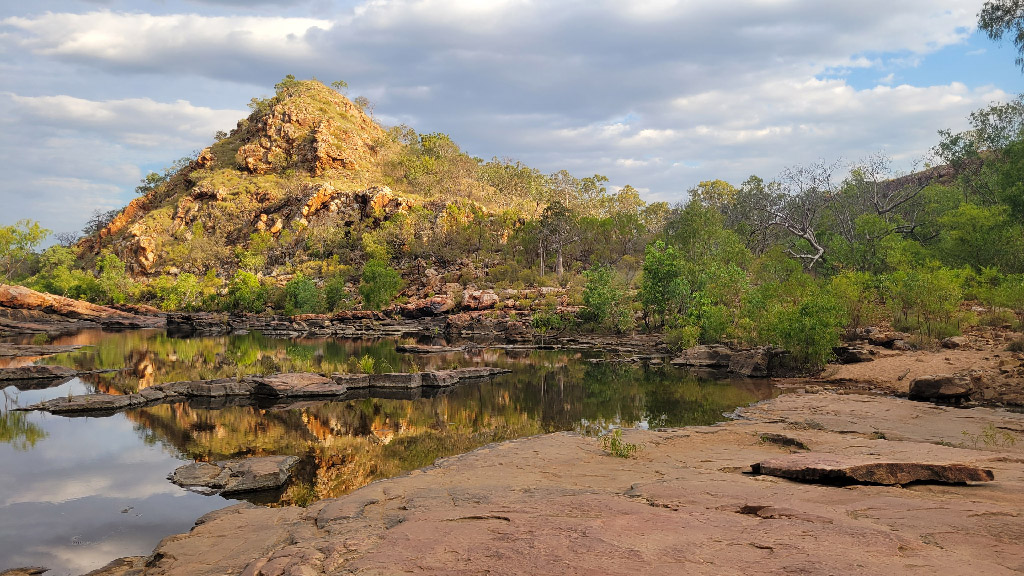
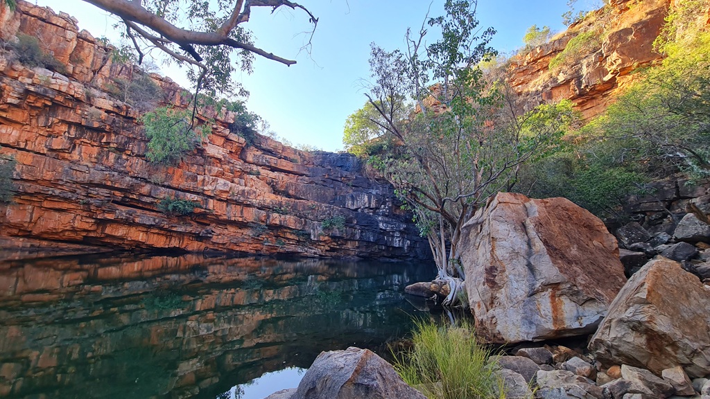
Warla Gorge
This gorge can be saved for the day after you arrive if you do not want to tackle the Wunnamurra Gorge. Alternatively, you could do this gorge in the afternoon you arrive and shave a day off your trip, or just relax: it’s up to you.
If you’ve been hammering corrugations all morning, Warla Gorge is the perfect place to relax. It’s a relatively easy short walk through paperbark-lined country to a deep, cool swimming hole surrounded by red cliffs.
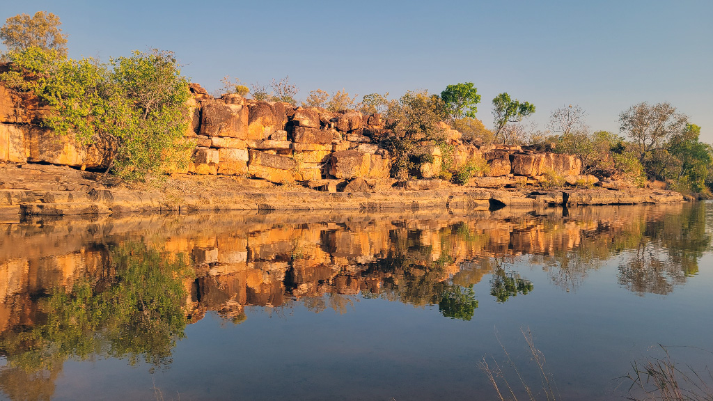
Wunnamurra Gorge (Day 7 Challenge)
This one’s different. Wunnamurra requires a serious 4WD track—steep descents, rocky sections, and the kind of driving that’ll have you questioning your tyre choice. Leave the caravan at camp; this is a day-vehicle-only mission.
The payoff? A gorge that feels completely untouched. The swimming hole at the end is deep, the walls tower above you, and you’ll likely have the place to yourself.
Not everyone will want to tackle Wunnamurra, and that’s fine. If your rig or confidence isn’t up for it, spend Day 7 relaxing at camp or doing a second Warla visit in a different light.
Days 8–9: Manning Gorge Campground (Mt Barnett)
Budget Tracker: Paid Campground (Manning Gorge Campground)
The run from Mt Elizabeth to Manning Gorge Campground is 68 kilometres of typical Gibb to the Mt Barnett Roadhouse—corrugations, creek crossings, and that relentless red dust.
At the roadhouse, you need to check in and pay for the camping. While there, grab any groceries you need (needless to say, it is not budget-friendly) and water. As you pass the gate, you can dump any rubbish that you have.
Manning Gorge Campground (Click for campground details) is a 7km drive along a narrow track from Mt Barnett Roadhouse.
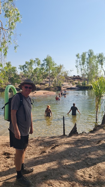
The Legendary Swimming Hole
Manning Gorge is, for many travellers, the highlight of the entire Gibb River Road. And we’re not going to argue with them.
The walk itself is an experience: you start by crossing the Manning River via a swim, pushing a cut in half blue drum in front of you with your gear in—it’s more fun than it sounds-, then follow a 3km track through monsoon vine forest to the gorge.
Muay’s Tip: keep in mind that there needs to be some drums for others to use. You may need to swim the drum that you use back before continuing the walk.
What you find at the end is a waterfall cascading into a swimming hole so perfect it almost looks staged. The water is fresh, the depth is serious, and the surrounding rock formations have been carved by millennia of wet seasons.
The Morning Walk Strategy (Day 9)
Here’s the move: wake early on Day 9 and hit the trail before the heat builds. By 7am you’ll be swimming in Manning Gorge with maybe one or two other early risers. By 10am, the day-trippers start arriving and the magic dilutes slightly.
Do the hard walk in the cool of the morning, swim until you’re waterlogged, then return to camp for a lazy afternoon. This is the Gibb done right.
Day 10: The Strategic Gorge Crawl
Budget Tracker: Free Camp (Frog Hole)
Today’s the day you rack up the gorge count. The drive from Mt Barnett to Frog Hole Campground is only about 38km, but you’ll be stopping a few times.
If needed, you can stop at the roadhouse for supplies, water and/or fuel. We found that you may be waiting a long time for the water.
Galvans Gorge
About 24 kilometres west of Mt Barnett Roadhouse, Galvans Gorge sits not far from the road. The walk in is short—maybe 500 metres—and the swimming hole is surrounded by pandanus palms with a small waterfall feeding the pool.
This is one of the most accessible gorges on the Gibb, which means it can get busy. Mid-morning tends to see the tour groups roll through. If you’re ahead of schedule, push on and double back later in the afternoon.
Frog Hole Campground
Your destination tonight is Frog Hole Campground—a basic bush free camp. After the station fees of the past few days, this is where the budget rebalances.
No facilities beyond what you’ve brought. No phone signal. No worries. Set up camp and relax for a while before discovering the next gem.
You can find information about this campground at Frog Hole Campground.
Adcock Gorge (The Late-Day Trick)
Adcock Gorge is easy to miss if you’re not looking for the turnoff. It’s a short drive off the main road followed by a moderate walk down into the gorge.
Here’s the trick: visit Adcock late in the day when most travellers have already pushed on to their evening camps. Around 4pm, the light drops into the gorge beautifully, the crowds have thinned, and you’ll likely share the swimming hole with nobody but the wallabies. We loved having the place to ourselves. Well, almost….
Just a word of warning. On our walk out, we discovered a freshwater crocodile sitting on a rock about 200m down from the falls. They are not dangerous, just be mindful that they may be around.
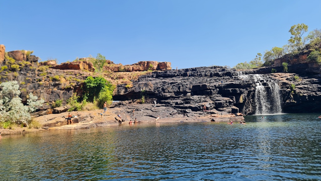
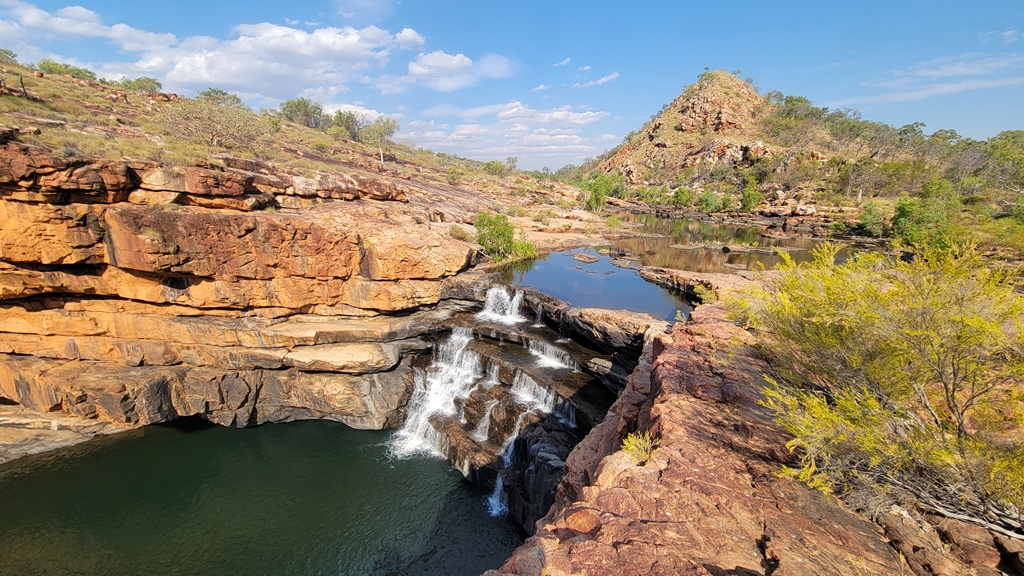
Day 11: The Icon (Bell Gorge)
Budget Tracker: Free Camp (March Fly Glen)
This is the day you’ve been waiting for. Bell Gorge is the poster child of the Gibb River Road—the image that graces every tourism brochure and Instagram feed from the Kimberley.
The drive from Frog Hole to March Fly Glen is fairly short at 65km. Use that saved driving time wisely.
Our March Fly Glen post has all the details you need about this campground.
If you wish to stay closer to Bell Gorge, there is a paid campground at Silent Grove. The fee to stay here is $20 per adult per night.
The Strategy: Set Up Early
March Fly Glen is the closest free campground to Bell Gorge, and better sites fill fast in peak season. Arrive by mid-morning, secure your spot, set up camp, have lunch, let the midday heat pass, and then head for the gorge in the afternoon.
The drive to the Bell Gorge carpark is 38km.
The afternoon light at Bell Gorge is spectacular. As the sun drops, the red rock walls glow and the tiered waterfalls catch the light in ways that’ll have you burning through camera storage.
Bell Gorge
The walk from the carpark to Bell Gorge is around 2.5 kilometres return—easy enough, but rocky in sections. Decent footwear is non-negotiable.
What you’ll find is a series of tiered waterfalls dropping into deep pools surrounded by ancient red rock. The main swimming hole sits at the base of the largest fall, and yes, it’s as good as the photos suggest.
Make sure that you do walk to the bottom of the falls, as some stop at the top.
A word of caution: the rocks can be slippery, the water depth varies, and people have been seriously injured here jumping from heights. Swim smart.
Day 12: Geological Wonders
Budget Tracker: Free Camp (Lennard River)
From March Fly Glen, the Gibb starts its final descent toward the highway. Today’s drive to Lennard River Campground is 85km, and the landscape begins shifting from red ranges to the limestone country that defines the western Kimberley.
Queen Victoria’s Head
Keep your eyes on the ranges as you approach Lennard River. Queen Victoria’s Head is a natural rock formation that looks remarkably like the profile of the old monarch—crown and all. If you are travelling from the west you will need to drive past the formation, stop and look back to see the likeness.
It’s one of those landmarks that feels almost too perfect to be natural. Stop for the photo; it’s basically mandatory at this point.
Lennard River Campground
Your home for the next two nights is Lennard River Campground—a designated free camp that’ll make your accountant happy after days of station fees and campground costs.
Facilities are basic (read: non-existent), but the location is perfect for tomorrow’s exploration. The river itself is beautiful, the bird life is prolific, and the sense of space is exactly what you came to the Kimberley for. For more information on this camp, see Lennard River Campground.
Rob’s Tip: Before you settle in for the evening, take twenty minutes to check your caravan brakes and wheel bearings. The corrugated stretches between here and Windjana are notorious for shaking things loose, and the last thing you want is a mechanical failure with Derby so close. We do this check religiously.
Day 13: Windjana & Tunnel Creek
Budget Tracker: Free Camp (Lennard River—second night)
Today’s a day trip into deep geological time. You’ll leave the caravan at Lennard River and explore two of Australia’s most extraordinary natural formations.
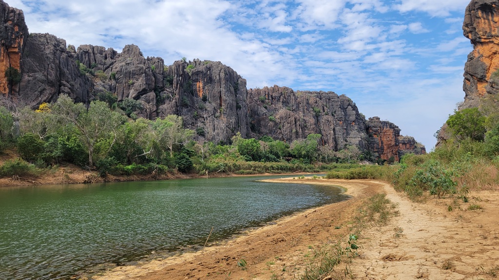
Windjana Gorge
Windjana Gorge cuts through the Napier Range—a 350-million-year-old Devonian reef system that predates the dinosaurs. The gorge walls are packed with ancient marine fossils, and the contrast between the white limestone cliffs and the red Kimberley dirt is striking.
The walk through the gorge is flat and easy, following the sandy bed of the Lennard River. Keep an eye out for freshwater crocodiles—they’re here in numbers, basking on the banks and generally ignoring tourists unless you get too close.
Entry fees apply (national park pass), but given your free camp situation, you’re still well ahead on the budget.
The gorge is a 21km drive from the campground.
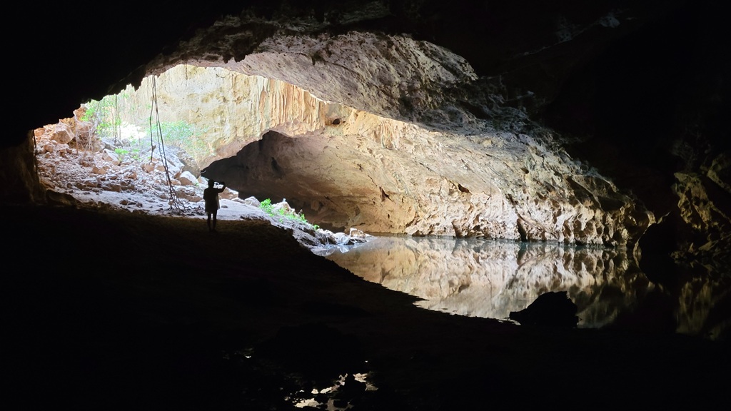
Tunnel Creek
About 36km from Windjana, Tunnel Creek is exactly what it sounds like—a 750-metre tunnel carved through the Napier Range by an underground creek.
You’ll wade through knee-to-chest-deep water in near-total darkness (bring a solid torch), navigating around freshwater crocs (sadly, there were none during our visit) and through chambers where the ceiling opens to reveal jungle-covered sinkholes.
This is one of the Kimberley’s most unique experiences. It’s also the hiding place of the Bunuba resistance leader Jandamarra, who used the cave system during his fight against European colonisation in the 1890s. The history here runs deep.
Day 14: The Victory Lap
Budget Tracker: Derby (various options)
This is it. The final day.
Pack up from Lennard River and point your rig toward Derby. You’ll be on the bitumen immediately, so air-up before leaving camp.
The moment, when the steering wheel stops fighting you and the cabin goes quiet, is one of the best feelings in overlanding. You’ve done it. You’ve driven the Gibb River Road.
The Run into Derby
The 125km of sealed road into Derby is easy and fast. After two weeks of careful line selection and tyre-pressure management, you might find yourself accidentally speeding. Ease off—there are plenty of wandering cattle and the local police know that Gibb finishers tend to get overconfident.
Derby
Derby itself is a working town, not a tourist hub, and that’s part of its charm. The famous Boab Prison Tree is worth a visit, the mudflats at sunset are spectacular, and the pub serves cold beer to people who genuinely need it.
More importantly, Derby has mechanics, tyre shops, and all the services you might need before continuing your journey—whether that’s south toward Broome or back east for another crack.
Western Gibb Essentials
Fuel: Mt Barnett Roadhouse is your key fuel stop between Gibb River Campground and Derby. Imintji Store (near Bell Gorge) also sells fuel but hours can be limited. Derby has multiple servos—fill up before you leave.
Water: Most paid campgrounds have water available. Mt Barnett allows access to water to everyone. At free camps (Frog Hole, Lennard River), you’re on your own. We carry minimum 100 litres for these stretches.
Gorge Access Fees: Some gorges require separate entry fees on top of camping. Check current pricing and have cash available—card facilities are unreliable out here.
National Park Passes: Windjana and Tunnel Creek require a national park pass. Purchase online before you go or at staffed entry stations.
The Budget Breakdown
Here’s how the western leg shakes out:
| Stop | Type | Notes |
| Mt Elizabeth Station | Paid Campground | Unique gorge access justifies cost |
| Manning Gorge (Mt Barnett) | Paid Campground | Includes fuel/supplies opportunity |
| Frog Hole | Free Camp | Basic bush camp |
| March Fly Glen | Free Camp | Bell Gorge access |
| Lennard River Campground | Free Camp | 2 nights, offsets station costs |
By alternating between paid stays (where the access or facilities genuinely add value) and free camps (where self-sufficiency pays off), you can do this stretch without breaking the bank.
Heading East? The Derby to Kununurra Reverse Itinerary
For those wishing to complete this trip in reverse, we have provided a summary table of the stays on the other part of this trip.
What You’ve Just Done
Two weeks. 660-odd kilometres of unsealed road. Countless river crossings, corrugations, and gorge swims.
You’ve driven one of Australia’s great adventure roads—not as a passenger on a tour bus, but in your own rig, at your own pace, making your own decisions. That’s something worth being proud of.
The Gibb has a way of getting under your skin. Most people who drive it once end up coming back. The gorges look different every year, the road conditions change, and there’s always another deviation you didn’t have time for.
If you have the time and the energy, you may want to consider tackling the Gibb’s lesser-known cousin. Duncan Road is an abandoned section of the highway to Wydam. We cover this adventure in our 8-Day Bungle Bungles & Duncan Road Loop itinerary.
For our stay in Derby, we camped at Kimberley Bushstay.
See you next time.
Other Pages in this Series
- General Information about the Gibb River Road
- Towing the Eastern Gibb: Kununurra to the Mitchell Falls Turn-off: this are the details for days 1 to 6 on the 14 day itinerary.
- Mitchell Falls Side Trip: A 3-Day Caravan Guide from the Gibb: a side trip to Mitchell Falls
- The Gibb River Road Express: 8-Day ‘Best of’ Caravan Itinerary: for those with only 8 days available but want to hit all the best places.